How to Use Your Garmin eTrex GPS for Bikepacking

Learn how to plan a bikepacking route using free maps and free apps. While there are many cycling-specific GPS units in the market, one non-cycling specific unit is the golden standard in bikepacking navigation. The Garmin eTrex series GPS units check all the boxes when it comes to usability and reliability.
(Update from July 20th, 2019: Garmin just released updated versions of their eTrex line of GPS devices. Even though I have not tried loading new maps into the eTrex 22x and eTrex 32x (the new models), I have no reason to believe that the steps below would not work on these new models. Let me know in the comments below if you have any issues loading free maps on the eTrex 22x and 32x devices.)
GPS Choices
There are so many GPS units on the market, ranging from very specialized ones to generic application units, that it might seem hard to narrow down your options to a few backcountry-worthy devices. Garmin’s eTrex Series of GPS units have become the golden standard in bicycle travel and bikepacking because of a few reasons:
- Reliable signal: You won’t be lost in the backcountry. eTrext GPS uses both GPS and GLONASS satellite systems.
- Versatile power options: No need to worry about finding the next outlet. This unit can be powered by normal AA batteries or rechargeable batteries.
- Low power consumption: My eTrex 20x can run for 4-5 days on a fresh set of batteries.
- Expandable memory: You’re not limited by manufacture’s spec. You can add more memory through the MicroSD card slot.
- Water Resistant: Getting wet is inevitable in the bikepacking world. eTrex units are rated IPX7, meaning they are resistant to rain and snow and can be submerged up to 1 meter for 30 minutes.
- Price: eTrex 20x and 30x are some of the most affordable units on the market.
To me, the biggest determining factor in choosing the eTrex 20x is the battery life and the ability to use regular AA batteries. Knowing that I can just swap batteries if I run out of juice gives me great piece of mind. If you have used a cell phone for navigation, you know how stressful it can be having to worry about your battery levels. This is especially true if you don’t have a dynamo hub on your bike.
Garmin eTrex Series
There are currently a few offerings in the eTrex series, but I’d like to focus on the 20x and 30x GPS units. There are only a couple of differences between these two models: the 30x has an electronic compass, a barometric sensor, and a higher price tag. These devices don’t have the fancy touchscreens their siblings have and that’s exactly what I love about them – their simplicity.
The new offerings in the eTrex series are an improvement over the already very popular eTrex 10, 20, and 30 devices. The new devices have a better display, better reception, and increased memory capacity. If you already have a compass and don’t care much about determining altitude with a barometric altimeter, you should save some cash and settle for the eTrex 20x.
When I was choosing a GPS device, I ruled out the touchscreen devices right away. Touchscreens don’t work very well when wet or when you are wearing gloves. I’m one of those people who wears closed finger biking gloves even during the summer. The navigation button (joystick) on the non-touchscreen units is very responsive and reliable. I didn’t see a need for a touchscreen. Also, the touchscreen versions have a lower battery life.
Garmin eTrex Guide
This guide is based on the device I own (eTrex 20x), but it is applicable to most GPS units out there. Likewise, this guide will be focused on bikepacking and bike touring navigation, but you can reference it for other applications like bikepacking, skiing, or any other kind of backcountry navigation.
Weight Weenies Will Dig This
This device is not only one cheapest units out there, but it is also one of the most light-weight units in the market in this category. I can’t say that I put too much thought in how heavy my navigation system is but I was presently surprised to find out that the eTrex 20x clocks in at 99 grams (3.5 ounces) without batteries and memory card loaded. When adding the much-needed batteries and expansion memory card, the weight penalty only increases 30 grams (1 ounce) This brings the total weight of the unit to 130 grams (4.6 ounces). To put things in perspective, my Crankbrothers tool weighs 180 grams (6.3 ounces).
Loading Shiny New (Free) Maps
Most GPS devices will come loaded with so-called basemap. These basemaps are very basic in nature and are not suitable for navigation. This means that you have to load a more detailed map before you can use it for bikepacking navigation.
One of the great things about these GPS devices is that you can load free maps. Branded maps, like the ones Garmin themselves sell, can be pretty expensive. With the advent of open source maps, like OpenStreetMaps, you no longer have to pay to have high-quality maps. There are 3rd party websites that will do all the legwork for you. All you have to do is transfer the detailed map to your Garmin eTrex.
This might seem like a long process with many steps, but it is actually pretty straightforward. I’m including a lot more detail than you probably need. But that’s a nice thing I’m doing for you:). Have a microSD card and a memory card reader will make things faster, but it is not needed.
Here’s a step by step guide on how to load free maps on your Garmin eTrex:
1) Download Maps from 3rd Party Services
There are a few free (and paid) services out there, but I usually use bbbike.org. I have also used Talky Toaster and garmin.openstreetmap.nl.
Once you get to bbbike.org, you have to select the region on the map that you would like to download. Keep in mind that the bigger the area, the larger the final map file will be. You can use the polygon tool to fine-tune the coverage area. This way, you won’t be downloading information that you don’t need. This is also where the expansion memory card comes in handy, so you don’t run out of space on your device.
Make sure to select a compatible format with the eTrex 20x. Any of the Garmin (latin1) formats should work. I like the Openfietsmap Lite style.
(The screenshot below shows a selection for an ASCII encoded file. BBBike doesn’t offer this encoding anymore so select the latin1 encoding instead. UTF-8 encoding does not work on many Garmin devices)

Go ahead and click the extract button. At this point, magic will happen. Basically, this service will download all the information from OpenStreetMaps and package it in a way that Garmin devices can understand.
You will receive an e-mail with a download link when your Garmin map is ready. This should only take a few minutes, but the time will depend on the area you selected. While I waited for my map to be ready, I took some time to donate some money to the creator of this service.
At this point, you just have to transfer the gmapsupp.img file to your Garmin’s microSD card, making sure the file is placed in a folder called Garmin.

2) Transfer the Map File
Insert the microSD card in your computer. Before you transfer the map file to the memory card, you have to make sure there’s a folder called Garmin.
Now that you have created the necessary folder, move the gmapsupp.img file you downloaded to the Garmin folder.

There’s only one problem. If you use two different maps from the same service, they might have the same name. Even if you rename the .img file, that will not change the display name the eTrex 20x. I recommend changing the name of your map using JaVaWa Device Manager.

3) Activate the Map
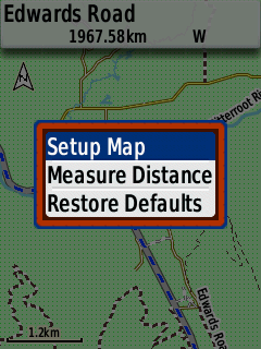
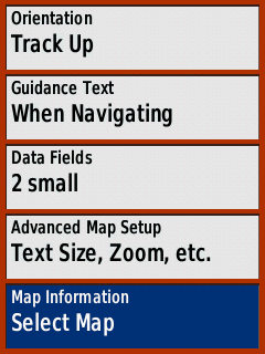
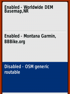
The last step in the process is to disable any other maps on your device that don’t cover the same area you will be in. To do this, while on the map is being displayed on eTrex, push the setup button to bring up the context menu. Select Setup Map and then Map Information. Now, select the map you want to disable.
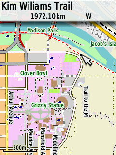
Finally, this is what the map will look like on the device. You can see the details for the city of Missoula, Montana.
Planning the Route
I usually use ridewithgps.com to design my routes. There are other apps that will assist you in creating a route, but I find Ride With GPS to be the easiest one to use. This app is able to import existing GPX tracks, a feature that Strava lacks. When creating my route, I make sure to use OSM Cycle as a basemap. This way, the map on my Garmin eTrex will match the map I used to create the route.

After you are happy with your route, you can export the GPX Track. This is very easy to do inside the Ride With GPS app. Just select the EXPORT tab on the right panel, and click the GPX Track (.gpx) hyperlink.

At this point, you could just load the .gpx file on your device and get out and ride. But I usually take a couple of extra steps to clean-up the route a little bit. I run through the route in Basecamp (Garmin’s desktop mapping application) trying to spot inconsistencies, fixing any routing glitches. Also, Ride With GPS will export what Garmin devices understand as tracks, meaning it will not be able to give you turn-by-turn directions. If you want turn-by-turn navigation, you need to convert the track into a route.
These terms are a bit confusing since each mapping app/provider uses slightly different terms when referring to a routable track. Garmin considers a track a breadcrumb-style track, with no turn-by-turn features. A route, in Garmin’s terminology, means that the track can be used for turn-by-turn navigation.
The connected green squares represent a route, while the footprints represent a track.

To make matters even more complicated, the eTrex series of GPS units (like many other GPS units), have a limitation on the number of waypoints that a route can have. If you create a route with more than 250 waypoints, the eTrex will not only not give you turn-by-turn directions after 250 points, it will also cut off your route short. I learned this the hard way when my route ended abruptly some 20km short of my destination while biking across the Scottish Highlands.
Considering that we are talking about a bikepacking route, a route will most likely have more than 250 waypoints. I recommend making sure that you have a track.
To Recap
- Create the route using your favorite application
- Export the route as a GPX file
- Import the file into Garmin’s Basecamp application
- Clean up the route, fixing routing glitches
- Make sure you have a track in Basecamp (not a route)
- Transfer the route to your device
Tips and Tricks
- It’s possible to transfer files using your phone microSD slot.
- You can customize the (2) data fields displayed while navigating on a map.
- If you use certain menu options frequently, you can customize the back button to flip through different screens.
| WEIGHT (w/ batteries) | 130g (4.6 oz) |
| PRICE (street) | $170.00 |
| CONTACT | garmin.com |
| AMAZON LINK | LINK |
Affiliate Links
By using the links below you are helping out the website without any additional cost to you. Every time someone buys an item through these links, the website gets a very small commission. In addition to only providing relevant links to the article, I keep all the ad links at the bottom of the page so they don’t junk up the website.


Hey- This is an incredible step-by-step set of instructions and I really appreciate it. The only issue I am experiencing is downloading the maps from BBBbike.org to my sd card. You mention a gmapsupp.img file being generated and sent to you email when you hit ‘extract’ but I am getting a .zip file (planet_-82.537,28.295_-81.374,29.165.osm.garmin-opentopo-ascii.zip is the full name) and I am not able to pull it up on my etrex. I am not sure what the reason is, but I do suspect it has something to do with the file being a .zip not a .img. Do you know how to prevent this when extracting a file?
Again- this is by far the best write up I have found for gpx files on the etrex. Thanks so much.
Hi James, thanks for the compliments. The .zip file is a compressed file that contains the .img file inside. On most computers, you can just open the zip file the same way you open a folder. The zip file has five files inside, but you only need the gmapsupp.img file.
Do you need to put that file in a specific folder, or just drop it in the device? I’m trying to do it without a memory card as the file isn’t very large.
Hi James, if you are dropping it directly onto the device, you still have to put the map file in the “Garmin” folder. Just drop the .img file in the folder and it should show up on your device. Remember that you have to activate the map (step 3).
Yes, you were right.. I figured it out. I used the same map format as you (Openfietsmap Lite) but noticed it does not offer any topographic features. Is there a way to include contour lines with this style, or do I need to find another map service?
Hi James, I can’t confirm right now but I think the map has contour lines. Check you eTrex setting for when to show contour lines. I’ll be able to confirm this weekend for you.
Great guide Andre and good tips on tweaking things. I was amused with the images as I have visited Madison a few times, am partial to New Glarus Spotted Cow and have ridden around Madison (in January!!) and the route to Verona to visit Epic
Nice! Thanks for the compliments.
Hi Andre thanks for sharing this information, it was just what I was looking for. Now for a question off topic. What mount do you use for your Garmin? Lots of conflicting advise on the web. Yours looks neat and tidy. Cheers
Hi Narelle, not off topic at all. I get asked this question a lot and should probably update the article with this information. I use this mount on my stem (http://amzn.to/2CM5CcE). Works really well.
I am having trouble activating the polygon/draw tool as well as the device selector. Did they remove it?
Hi Caleb, I think you mean the file format when refering to the device selection. Any of the Garmin file formats should work. The polygon tool is still there. Look for a message that says “move the map to the desired location. Then click here to create a bounding box”
Just got my eTrex and managed to figure this out using a dozen different sources. Super nice to have this all in one place without all the talk about basecamp and the like. I was looking to configure the back button so that I can just use that on most trips when I came upon your site.
Ecxellent piece of information to help me decide my gps confusion. All I need is a course, or track, to follow with some directional guidance and better than average battery life. The Etrex fits the criteria perfectly.
Just one question if you can confirm, Is either the 20x or 30x able to connect with a heart rate monitor?
Regards,
Rick.
Hi Rick, the eTrex GPS devices don’t have any wireless connectivity and cannot record data from a heart rate monitor. If that’s important to you, you might have to look into a sports GPS device.
Thank you Andre. From your post it seems the 20x would be the logical choice.
Regards,
Rick.
That is not true, at least for the 30X. It records data from heart rate monitor. you only need an ant+ heart rate sensor/strap.
Here is an example of mine: https://connect.garmin.com/modern/activity/3507957800
About wireless connectivity, it can connect to ant+ garmins, which I find kinda useless.
That’s true, I missed the fact that the 30x can connect to a heart rate monitor. The 10x and 20x cannot. Thanks.
Can anyone confirm yeet that these instructions work for the 32x?
Alison, other websites confirmed that this will work on the new eTrex models. This also works in plenty of other Garmin models. I should probably update the article with this information.
Hi Andre,
Great article – thank you writing this. Where you have more than 250 waypoints and say to use a ‘track/breadcrumb trail’ instead, can you have an ‘unlimited’ breadcrumb trail? What does the actual breadcrumb trail look like when navigating ?
Hi Nick, Garmin limits the “tracks” to a maximum of 10,000 points. On your device, it will look like a line connecting the points. “Routes” can only have a max of 250 points.
I think on the Etrex 20x (at least) the MicroSD can’t be bigger than 32gb. You guys could confirm me that, but it seems true (and also a not-that-visible) true since I came up this info on Garmin Express. Good to know that before buying a 128gb one, like I did. Excellent guide and excellent website-project, @bukeundbier. Cheers!
Hi Álvaro, good to know the article was useful. The Garmin support page says all of their outdoor handheld devices only accept microSD cards of up to 32gb. I’ll see if I can find a spot in the article to add this information. Cheers
When you replace the batteries on a long adventure is there any loos of rout/track or other issues?
I plan on using this on multi day bikepacking races and don’t want to get in a pickle in unknown territory. Thanks for the awesome review!
Hi Jon, you don’t lose any information when you switch batteries. All the information is stored in persistent flash memory.
Hi Andre, thanks so much for this guide. It’s super useful!
I’m considering buying an extrex because of the AA batteries. However the whole waypoint issue really worries me. How do I go about planning a 2000km trip? If I just split the trip into multiple routes (one route for each day of cycling) would that work? Say it’s route has 250 way points but I create 27 routes.
The trip I’m thinking of doing is John o Groat’s to Lands End and sustrans sells a GPS file for the trip following just small roads and cycling paths, but after reading about the waypoints I’m not sure the sustrans file would work?
Also can extrex give you on the spot navigation or it can only follow the route you have already planned on your computer?
Sorry for all the questions! Trying to figure out whether that’s a good GPS to buy has given me a headache those past weeks.
Hi Electra, it’s a little confusing but the 250 waypoint limit is for “routes” only. That’s why I recommend creating a “track” for bikepacking. eTrex devices can have up to 10000 track points in a track. Here’s a link that does a better job explaining the difference between Routes and Tracks. I still recommend cleaning up excess track points from the GPS as a file with many thousands of points can be a little slow to load. I use Garmin’s free software Basecamp to clean up my GPS files.
You can select a point/destination on an eTrex device and it will calculate a route for you. It will only follow established roads/paths on the map that you have loaded though. This is very handy when in a city and you are trying to find your way to a local grocery store (or pub).
John o’ Groats to Lands End sounds amazing. Yeah, most people would break the GPS file into multiple sections so it is easier to follow. I usually break mine up based on where I plan to spend the night.
thanks so much Andre!
Hi. Great article. Do you know if this will work with an old eTrex vista hcx from around 2007? The new maps on Garmins site don’t so if the free ones do, great, because this gps works really well. Thanks!
Looks like it does according to this OSM Wiki Page. There might be some limitations though. For instance, looks like the map name cannot be longer than 8 characters. There are tools out there that you can use to change map name before loading on your device. Check out JaVaWa apps to manage your maps.
Hi André, just wanted to thank you for your article. Got myself eTrex 32x recently and was fighting the logic behind the unit operation. Your article has taught me some new things such as configuring the Back button which is great! Also the external links you gave I find very useful, especially JaVaWa, will test it when I get to my PC, but it already seems like a very handy piece of software.
Oh, one more thing, I wanted to bring to your attention my favorite route planner (if you don’t know it already): http://brouter.de/brouter-web/ – it has routing profiles, you can define no-go areas and add POIs on your route, and exported GPX files work well with Garmin devices
I read somewhere that The 32x differs from the rest of the lineup by offering a barometric altimeter, compass, ANT+ compatibility, and the ability to add custom maps. So this works on the 32x, but not on the 22x?